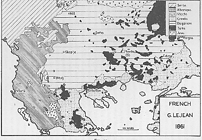
Map
of G. Lejean, French (1861).
Lejean was sent in a journey to the Ottoman
Empire to gather information for the French
government. His observances of the ethnic
composition of the areas he visited produced
this map.
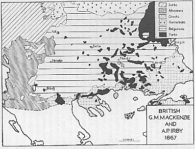
Map
of G. M. Mackenzie and A.P. Irby, British
(1867).
The two ladies, Mackenzie and Irby, traveled
through the Balkans to show the essentially
Slavic nature of the peninsula. They did mark
what they concluded to be Albanian inhabited
lands.
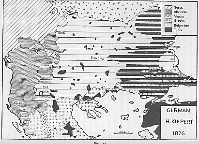
Map
of H. Kiepert, German (1876).
Kiepert was a professor at the University
of Berlin. He had knowledge of Balkan history.
He also inquired official sources in Istanbul
and was influenced by the Greek historian
P. Aravantinos (1856-7).
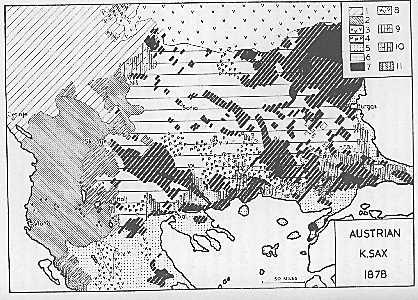
Map
of K. Sax, Austrian (1878).
Karl Sax was a consul of the Austria-Hungary
Empire at Adrianople. He was well acquainted
with Balkan affairs and had cultivated an
intellectual interest in cartography. He made
use of previous maps and official reports
of populations by Austrian and Bulgarian offices.
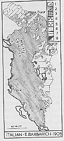
Map
of E. Barbarich, Italian (1905).
The Italian E. Barbarich published a book
about the Albanians which contained an interesting
map. He interpreted Albania in a very liberal
manner to include the whole of Epirus, western
Macedonia, the whole of the Drin valley and
Kosova.
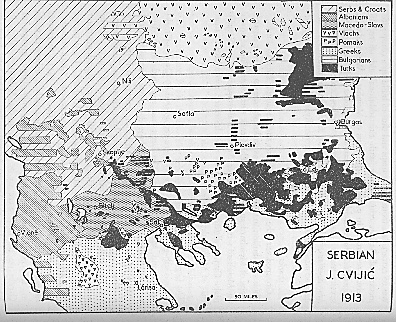
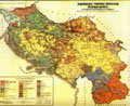
Map
of J. Cvijic, Serbian (1909).
A map showing the pro-Serb view and a reflection
of Serbian policy of the time. As far as Albania
is concerned, Cvijic asserted that the northern
region was inhabited by albanianized Serbs
and most of the south by albanianized Greeks.
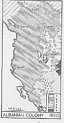
Map
of the Albanian colony in Istanbul (1920).
This was the first map produced by Albanians,
namely, it was produced by a colony of wealthy
Albanians living in Istanbul. This map was
the basis of Albanian government of the time
proposition of Albania's boundaries.
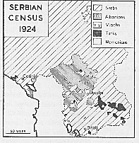
Serbian
Census of 1921.
This map was produced by the Serbian government
as a result of the 1921 census of the Yugoslav
kingdom. To distinguish nationalities it used
the 'mother-language' criteria. It clearly
shows Kosova to be predominantely Albanian-speaking.
Map
by the German Foreign Office (1940).
This highly detailed map was produced by the
Geographical Division of the German Foreign
Office and it was based on local official
information.
British
P.C.G.N. (1942).
The Permanent Committee on Geographical Names
for British Official Use produced this map
in 1942. The method used was a simple shading
of linguistic zones.
These maps, except the German Foreign Office map,
were taken from the book Maps and Politics, A
Review of the Ethnographic Cartography of Macedonia
by H. R. Wilkinson (Liverpool: University Press,
1951).